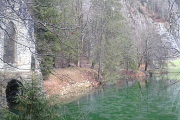
© Alison Shayler

Promenade d’Arve Towards Les Houches
A simple walk from Chamonix centre towards Les Houches
Getting around the Chamonix Valley and up into its high mountain terrain is made easy thanks to the extensive transportation network available. The local buses that take you to all the main gondola and cable car stations are free with a Carte d’Hôte (Guest Card). You can get your card on arrival at your rental accommodation or hotel.
Cable cars and chairlifts are used widely by walkers and climbers alike, whisking you up to around 2,000m, or taking you back down. Using the lifts can cut a good two hours off a walk, thus enabling you more time to enjoy the views at a higher altitude without unnecessary slog. The lift system comes into its own in the event of deteriorating weather, injury or just plain tiredness, when it will swiftly transport you back to the valley floor (providing you are within the lift operating hours).
The river de L'Arve runs through the entire Chamonix valley and there are essentially two directions one can head from Chamonix. Down the valley down towards Les Houches, or up the valley towards Argentiere and Le Tour. The following two routes are two of our favourite river walks:
Suffice to say, whichever direction you choose, both riverside paths will provide some colourful plantations and spectacular panoramic views of the massif.
Promenade d’Arve – towards Les Houches
This is a leisurely walk, following the right bank of the river Arve on the south side of the valley.
Starting Point: Chamonix
Duration: Two hours (one way)
Starting from the crossroads Lionel Terray, follow the Route des Pecles to Les Gaillands. Three lakes, known as the mirrors of Mont Blanc, lie in the wooded area near the Rocher d’Escalade (natural climbing wall). Continue along the Promenade a l’Anglais through a small wood, crossing the Ravin des Vouillouds above Les Bossons.
After passing Les Montquarts, cross the Lapaz ravine then once level with the Pont de Clair-Temps (a railway bridge), the path climbs slightly into the forest of les Roches; then joining the Chemin des Eaux Rousses. Follow the path which arrives at the bridges at Les Gures (EDF dam and railway station), at the crossroads of the Route de Coupeau.
You can return by the same route (two hours) or catch the train or bus from Les Houches.
What to bring
IGN3630 map is recommended