© TAR

© P.Williamson

© P.Williamson

© P.Williamson

© P.Williamson

© P.Williamson

© P.Williamson

© P.Williamson

© P.Williamson

© P.Williamson


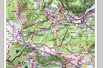
A Recce of the Route for the P'tit Trail des Aiguilles Rouges
With the UTMB behind us we can look forward to the TAR!
The town of Chamonix gets taken over at the end of August each year with trail runners from all over the world coming together for the UTMB - the Ultra Trail du Mont Blanc. And once that is over, it is the turn of the smaller event the TAR - the Trail des Aiguilles Rouges.
It does seem that from start to finish the summer in Chamonix is taken up with running events, which for a mountain biker like myself, is not really that exciting! Having said that I did let myself get talked into helping a friend train for the Mont Blanc Half Marathon earlier in June; and that same friend seems to have fooled me once again into helping her recce the route for the P'tit TAR.
So dutifully, last weekend in about 35 degree heat we took the bus to Les Houches to begin our journey. The P'tit TAR, the little sister to the 50km full TAR, is a mere 15km with 1200m ascent/descent, up and down the pretty peak of Mont Lachat (height 2023m).
The route, rather strangely starts at the Prarion lift, even though the peak itself sits above the Bellevue lift. I can only assume that this is to add to the distance so that it makes a good 15km... The start however was fairly uninspiring - a scramble up the home run (piste) at Les Houches, through knee tall grass and nettles, climbing over, under and around fences. Let's hope that this will be more of a path by the time the race comes! It starts as a bit of a slog, straight up towards the Maison Neuve car park, and then finally joins a nice path that leads you across the Les Houches resort and into the forest.
The forest section gives you some respite from the sunshine and was surprisingly cool, but the trail however, is relentless. For the next hour we followed the steep path as it passed by landslides, cliff faces, crossed streams and eventually flattened out. At least with a steep path you gain altitude fairly quickly and before we knew it we have travel a good 800m of our height. The path, as well as being steep is fairly narrow in some places - and not for those who are afraid of heights as there is often a steep drop off the side. The views are stunning though and it was great to see the valley from a different angle. Looking both back up towards Le Tour and over towards Servoz and the Vallee de l'Arve. The slight downhill section between kilometres 3 & 4 is perfect for a bit of recovery time, although you can't help but be a little upset at the height you lose, especially after it was such a struggle to get up there in the first place!
Luckily it is a fairly short burst of flat, and slightly downhill trail, before snaking its way up again on another narrow steep path. Hard work for sure, but there was no denying the beauty of the area and the views. Around 6km in we finally came to the sign that indicated just one more hour to Mont Lachat. At this point you are looking a the wide couloir that runs down from Col du Mont Lachat and it is prime marmot territory, with their piercing whistles coming from all sides.
Even though the end was insight at this point I still found it difficult to keep up a sprightly pace, although to be fair, I'm not the one running the race, so who cares! Once we hit the top of Mont Lachat and spent a bit of time enjoying the magnificent view and having a chat with a older French couple who were also there. They pointed out the warning sign to us and asked if we knew what route it was referring to. "Difficult path. Steep slope 300m". We felt it was definitely not the way we had just come so wondered to ourselves what was in store for the way down...
Now one good ting about this race route is that it is pretty much 1200m straight up and then 1200m straight down. So you know where you stand at any point in the race, there really is very little in the way of undulation. However, I don't think anything prepared us for the 300m steep descent that we took on next. Again, I can be thankful that I am not taking part in this race as trying to get down this narrow, loose steep path with a few hundred other participants is certainly not my idea of fun! It was probably at this point that I started wondering if all the other walkers we had passed had the right idea - walking poles.
Once we had made it down this portion of trail it was only a few hundred metres to the Bellevue cable car and at this point I was happy to call it a day and take the cable car down. After 4.5 hours of hiking (not running!), a few wrong turns and quite a lot of route finding I was happy that we had made it to the top of Mont Lachat but I am sad to say that I am not a good enough friend to put myself through a further 800 metres of descent just for the fun of it.
So suffice to say, I am overjoyed not to be participating in the P'tit TAR, but I would also recommend the hike to the top of Mont Lachat as a fantastic walk in the Chamonix valley! It was so different to many of the walks I would normally do, and gave us the most amazing views. Plus, despite the random route we took to get up there, there is actually a very nice accessible path from Les Houches centre and others close to the Bellevue lift. Or you have the option of taking the lift up and walking down, or even taking a ride on the scenic Tramway du Mont Blanc and then walking down...