


Chamonix Activity Report: 15th September 2005
With the continuation of the sunny weather we have been enjoying in September we have been able to keep up with our hiking, and recently took the trail up to Chalet du Glacier on the left bank of the Glacier des Bossons. This is the more popular route up to view the glacier and also the route taken by the first Alpinists to reach the summit of Mt Blanc in 1786 (namely Dr Paccard and his guide Jacques Balmat, a statue of whom can be seen in Place Balmat in Chamonix town centre). People aiming for the Mt Blanc Summit still commonly use this route
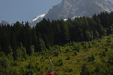
We cycled to the foot of the Les Bossons chairlift (Telesiege du Glacier du Mont Blanc) and took the sign posted route up to the chalet restaurant on foot. You can also catch a bus from Chamonix town or drive yourself, as there is quite a large car park from when the chairlift used to run during the winters; sadly it no longer does and only opens for hikers in the summer. The chairlift takes you to the foot of the chalet and costs €6.50 to go up, €4.50 to come down or €9.50 return
On foot, the path zigzags around and offers varied scenery as you cross woodland, fields and loose rock. The gradient is fairly steep but easily manageable (though not with a hangover – note to self: don't drink too much the night before a planned hike!) and we passed lots of people walking dogs or with small children
The chalet looks like a great spot for lunch with a pretty extensive menu and stunning views of the glacier. On display – and not quite as macabre as it first sounds - are the relics of two plane crashes both found on the glacier (the engine from Kant Chenjunga and the landing gear from the Malabar Princess) with information on when the planes crashed and how it took around 40 years for the wreckage to be transported under the glacier and down the mountainside. The chalet owners publish a booklet on the colourful history of the glacier in various languages
You skirt around the edge of the chalet terrace and plane remnants to reach the viewing platform for the glacier. On route there are several highly informative boards offering everything you could ever wish to know about the history, formation, movement and activity of the glacier, complete with numerous photos (bring your dictionary as it is all in French)
The view of the glacier is impressive and noticeably closer than the view you get from the right bank (see report from 19th August). The seracs (large ice columns created when the glacier cracks over uneven ground), look enormous even from this distance and again we spotted a few dots of people ice climbing which all helps to put the scale of the mountain into perspective
This trip is quite an educational adventure and well worth the effort. It is then possible to continue past the chalet on foot and reach Chalet des Pyramides at the Plateau des Pyramides which should take approximately 1hr 30 and further still to La Jonction where the glacier meets the Glacier de Taconnaz. The full trip is a serious day's hike and should be planned well, we are eager to give it a go and may even take the chairlift up to the first section to give ourselves a head start
Piste Maps for Chamonix (pdf format), Les Houches (jpg format), Cross-country skiing (pdf format), and Mountain-bike trails (pdf format)
Current status for opening of Pistes & Lifts
Chamonix Webcam Index
Useful Links
Swiss Federal Institute for Snow and Avalanche Research
French Avalanche Research Institute
Meteo France - Mountain weather and avalanche conditions bulletins (in French)
Henry's Avalanche Talk - popular avalanche training sessions based in French Alps as well as translation of current avalanche conditions
PisteHors.com - Backcountry Skiing and Snowboarding News in English for the French Alps. Excellent coverage of avalanche safety and advice
Additional snow and weather information provided, with thanks, by meteo.chamonix.com and the Tourist Office