© Alison Shayler

© Alison Shayler

© Alison Shayler

© Alison Shayler

© Alison Shayler

© Alison Shayler
© Alison Shayler

© Alison Shayler

© Alison Shayler

© Alison Shayler

© Alison Shayler

© Alison Shayler

© Alison Shayler


Trail Running: Where to Find the Best Trails in Early Spring
A quick look at which trails are clear of snow and where is good to run at the moment
It's now less than three months until the Marathon du Mont Blanc and time to start hitting the trails to get ready for running season!
Although I’m made up that this week’s wet weather has brought us new snow up top, the rain and wind hasn’t exactly had me motivated to head up the mountain, I’m more than happy to wait until the clouds have cleared and sunny spring conditions are back. In the meantime I’ve dug the running shoes out from under the bed and been out to check on the condition of some of my favourite trails.
Generally, most valley level trails are all clear of snow now and depending on the aspect there is good running terrain up to quite a high altitude for this time of year. I did all of the routes below without hiking poles or crampons and didn’t really feel the need for them. All times given below are based on average hiking time, how long it takes to run them is up to you!
LE PETIT BALCON SUD
I was a bit wary of this one as I’ve attempted it early in the season before and ended up staggering through leg shredding icy slush, so I was pleasantly surprised to find it almost completely clear the whole way! Starting from the Golf Club de Chamonix I followed the trail into the forest and took the higher trail to Argentiere via La Joux. This is one of my favourite trails in the valley featuring loose stones, tangled tree roots and slabs of rock interspersed with lots of nice springy forest floor. The distance is only about 6km but it is a good warm-up for the legs due to the undulating and varied terrain. Once you get to Argentiere you can either get the train or bus back to Chamonix, or you can do as I did and cross over to the Grands Montets lift station to pick up the Petit Balcon Nord back in the opposite direction.
Distance: 5.6km
Time: 1.5 hours
LE PETIT BALCON NORD
Once in the Grands Montets carpark carry on past the lift station until you are nearly at the exit, look out for the last road on your left that has a signpost for the Cremerie du Glacier. Follow this road up (past the signs for freerange chickens, goats, horses and children) until you see the return to Chamonix signpost pointing to your right.
I was a bit dubious about whether I’d bitten off more than I wanted to chew as the first uphill section to the old lift was pretty well covered in snow. It was fairly firm underfoot but slowed my running pace down to a steady trudge. It soon cleared up though and I was able to pick up speed once more. The good news is that all the places that are likely to avalanche have already done so, the bad news is that there is still a lot of avalanche debris strewn across parts of the trail. It’s passable but one little stumble could send you sliding down a rather steep and bumpy descent - I’d wait a couple more weeks to be on the safe side.
An alternative would be to carry on along the road from Argentiere until you get to Les Grassonets and then rejoin the trail just before Lavancher. From here on in the trails are fine and really enjoyable; lively rooty sections interspersed with soft Alpine singletrack. There are a few fallen trees to scramble over but that just adds to the adventure! I wouldn’t recommend taking the mountain bikes down there just yet though as some of the obstacles are pretty big.
Once you get past Le Lavancher you can either carry on through Les Bois back into Chamonix or bear right and weave through the small village back to the Golf Club de Chamonix and the start of the Petit Balcon Sud.
Distance: 8.5km
Time: 2 hours
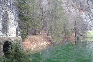
CASCADE DU DARD CIRCUIT
Starting from the Aiguille du Midi lift station this short but steep climb takes you up through the forest to a waterfall. Go behind the lift station and under the tunnel to the left of Concept Pro Shop, turn right and follow the footpath that leads past the carpark and then alongside the road until you cross a small bridge and turn left into the trees - it is signposted at regular intervals.
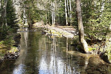
You follow the trail across another bridge and then look out for a small signposted path heading upwards to the Cascade du Dard. From here it is a quick but challenging ascent through pine forest and occasionally alongside a river to the waterfall. The café isn’t open yet but the view is still worth the effort. I was amazed to find barely a smidgen of snow the whole way up, I was thoroughly expecting to have to turn back but the ground was in excellent condition and quite dry. You can then either come straight back down or do as I did and add on an extra little loop by following the signpost to Chalet le Cerro.
This trail winds higher up and takes you under a bridge, bringing you out just before the entrance to the Mont Blanc tunnel. Rather confusingly the sign seems to be pointing directly out into the path of massive oncoming lorries but actually it means for you to double back and cross over the bridge, staying on the same side of the road, to access a small carpark from where you can pick up signs again for Le Cerro (it took me and three bewildered gendarmes to figure this one out). The only significant snow I saw was right at the last minute on the final push up to the chalet and it was well trodden enough that you can easily make the ascent without too much floundering. Once at the chalet you can either return the way you came or take the fun little singletrack path down to Les Bossons, from where you can pick up the last section of the Les Houches/Gaillands trail, as detailed below. I ran a bit of it then scooted back round to the tunnel and returned via the Cascade. The descent was really fun, the path is soft enough to have a forgiving bounce to it but not so damp that it is slippery - perfect for skipping back down to Chamonix!
Distance: 9km
Time: 2.5 hours
LES HOUCHES / GAILLANDS TRAIL
This one is the easiest of the lot, navigation-wise and is a great introduction if you’re getting used to trail running. Starting from Les Houches train station you head over the bridge that doubles back over the railway track and take the first small road on your right, you’ll pass some houses and farm buildings before the path becomes rougher underfoot and you enter the forest. It’s a fairly short run but is a good workout with a few little hills and fast descents. The shadier parts can be icy until quite late in the spring but I was pleased to find that the path is clear pretty much all the way along, there’s the odd sliver of snow left but nothing that you can’t tiptoe your way around. The trail brings you out at the lake and climbing wall of Les Gaillands, from where you can pick up the bus or train, or do the 10 minute road run to the centre of Chamonix.
Distance: 5km
Time: 1 hour
All of these runs start and finish on the main train and/or bus routes, so you can do them in either direction and pick up a lift at the other end.
I also have it on good authority that the Gaillands track up to Merlet is almost entirely clear of snow, apart from avalanche debris in the last couloir that you need to pick your way through. I should also mention that the bridge is not in place up there yet, so make your own judgement call on how safe it is before you attempt to cross it!
Happy Easter everyone and remember - the further you run today, the more chocolate you can eat tomorrow!