© Happy Tracks

© http://www.alain-collet.com/Alpes/TMB/187.html

© Alison Shayler


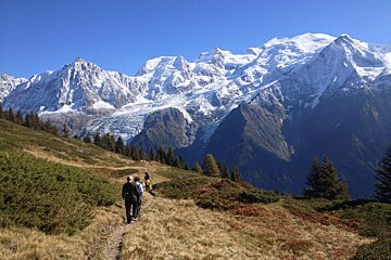
Aiguillette des Houches from Les Houches
A full day hike taking in some of the best views of the Mont Blanc Massif
Starting and finishing at the animal park in Merlet this full day walk takes in the summit of the Aiguillette des Houches, Refuge Bellachat and offers a magnificent panorama of the Mont Blanc Massif
A beautiful loop walk with blueberry bushes along the way and stunning flora that changes colour year-round, making it a beautiful hike from spring through to autumn.
Who should go
A long and committing hike not to be underestimated. For the more serious walker who can handle a big ascent and a long day under the hot summer sun.
What to do
Leave time to visit the Parc Merlet, many alpine animals are shy creatures but here you can see them close up and in their natural habitat.
What to bring
Take all the required equipment for a long day in the mountains. This walk can be found on the Chamonix - Mont Blanc Massif map IGN3630OT
What to see
Views extend beyond Chamonix into neighbouring valleys as you hike along the high ridge, looking across gives you a panoramic view of the Massif du Mont Blanc and the glaciers.
Where to lunch
Taking a packed lunch and enough water for the day is advised. The Bellachat Refuge is open during the summer months offering refreshments and, if needed, a bed to rest if the weather takes a turn for the worse.
Directions
Leaving the car park at Merlet animal park follow directions to the Refuge Bellachat taking in the views of the Mont Blanc Massif. A few meters past the Refuge you will see a cairn with a "Aiguilles Rouges Nature Reserve" sign, here you turn left and head in the direction of the Aiguillette des Houches, the obvious high point. From here you get a 360 degree view of the Mont Blanc massif, the Aiguille Rouge and the Fiz.
Leaving the summit in the direction of Les Houches you will first come to some Rhodos in Pierre Blanche 1,679m. At this intersection turn left towards Le Plan de la Cry. Shortly before the Chalets de Plan le Cry go up the wide path to your left, rising just under 100m in elevation you will take the path that leads off to to your right (1,782m) and head back down to the car park at Merlet.