© Refuge Durier

© Refuge Durier


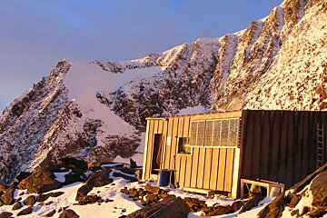
Durier Refuge (3358m), Massif du Mont-Blanc
A remote rustic refuge for experienced climbers and mountaineers
The Durier refuge is tucked away between the Bionnassay ridge and the Dome de Miage. This refuge is one of the more difficult shelters to access, taking approximately 7.5hrs and a 2200m ascent. It is certainly not meant for the casual climber. Especially as there is no heating or water and night time temperatures even in summer often drop below freezing.
This small refuge sleeps just 12 people in one dormitory; bed covers are provided but you must bring your own sheet or sleeping bag liner.
Accommodation can be booked on a half-board basis, with discounts for Club Alpin Francais members. The refuge does not offer kitchen facilities during the summer season, so self-catering is not possible.
The refuge is open and staffed between mid-June and the beginning of September. It can also be used during the winter; bedding and cooking materials are provided but it is unstaffed.
Please contact the refuge directly for this season's prices and opening/closing dates and to book on +33 (0)6 89 53 25 10. Due to the remote location, the refuge guardian advises that you call in advance of your arrival to ask their advice on weather and conditions.
Worth knowing
The hike up to the refuge is long and remote; there are very few water sources along the way so you are advised to carry sufficient drinking water.
Directions
Access to the hut is in two stages. Firstly, make your way to the Plan Glacier hut. Take the Bellevue cable car from Les Houches or the Mont Blanc tramway from St Gervais. Follow the path to the Col du Tricot. Once at the Col, take the path which contours the south west flank of the Tricot ridge. This leads to the Plan Glacier hut. Secondly, from the Plan Glacier hut, take the south east path towards the Miage glacier. Cross the Miage glacier taking a south west path to reach the cliff at the foot of the Col de Miage. Climb up the rocky spurs which lead to the Durier hut.