Chamonix Town Map
The file is a PDF document. It was last updated on and originally sourced from Chamonix Tourist Office.
© Mont Blanc Natural Resort
Download the essential Chamonix maps and plans
Download PDFs of the latest ski maps, town maps and trail maps in Chamonix.
Although commonly referred to as Chamonix, the Chamonix valley is actually made up of several towns and villages, each with their own distinct character. These include places like:
This means that within the valley, there are distinct ski areas, mountain bike trails and hiking routes.
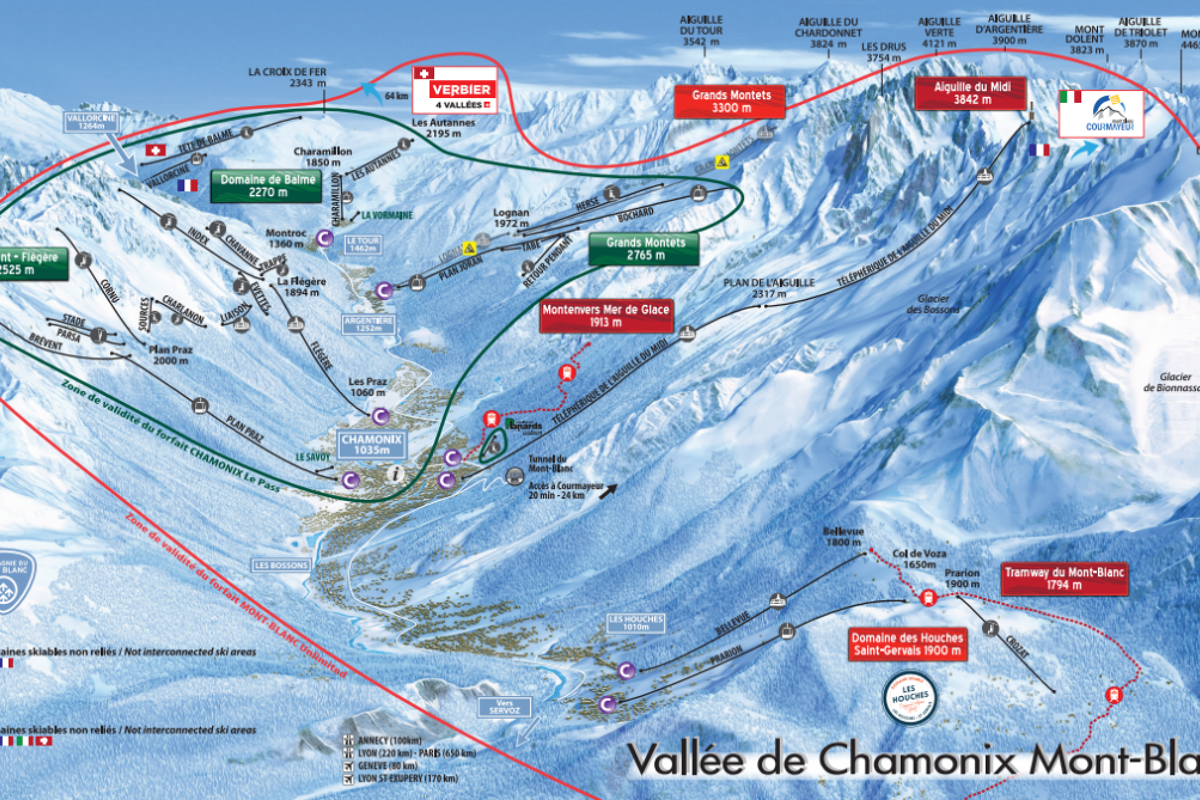
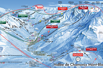
Chamonix Valley whole area piste map
Mont Blanc Natural Resort piste map
Brévent & Flégère piste map
Grands Montets piste map
Balme (Le Tour) piste map
Les Houches piste map
Les Planards beginners area piste map
La Vormaine beginners area piste map
Le Savoy beginners area piste map
Le Tourchet beginners area piste map
Evasion Mont Blanc piste map
Courmayeur piste map
The ski lifts are marked on the piste maps using straight black lines. There are four types:
If you see anything marked 'express', that means a fast, six-person chairlift.
These are the maps for the main towns and villages in the Chamonix Valley.
The file is a PDF document. It was last updated on and originally sourced from Chamonix Tourist Office.
The file is a PDF document. It was last updated on and originally sourced from Chamonix Tourist Office.
The file is a PDF document. It was last updated on and originally sourced from Chamonix Tourist Office.
The file is a PDF document. It was last updated on and originally sourced from Chamonix Tourist Office.
The file is a PDF document. It was last updated on and originally sourced from Chamonix Tourist Office.
Vallée Blanche and Mer de Glace map – winter map / summer map
Aiguille du Midi summit – winter map / summer map
Montenvers and Mer de Glace – winter map / summer map
Tramway du Mont-Blanc map
Don't ski or snowboard? No problem. Chamonix has plenty of snowshoeing trails where you can experience the clear air and crunch of fresh snow.
Grant Montets ski touring map
Grand Montets-Lognan ski touring map
Les Houches-Prarion ski touring map
Le Tour ski touring map
Chamonix is a hiking mecca and trails here are very well marked. Even so, it's always a good idea to know where you're heading in the mountains. These are the main Chamonix hiking trail maps.
Chamonix Valley hiking & walking map
Brévent & Flégère hiking & walking map
Grands Montets hiking & walking map
Balme (Le Tour) hiking & walking map
Les Houches hiking & walking map
Mont-Blanc Natural Resort summer area map
Evasion Mont-Blanc summer area map
The main downhill mountain bike trails in Chamonix are in Le Tour and Les Houches. Read our guide on mountain bike trails in Chamonix for our top tips and epic spots to ride in the valley.
Chamonix Valley & Servoz mountain bike trails map
Les Houches downhill mountain bike trails map
Saint-Gervais mountain bike trails map
For the best take-off and landing spots in Chamonix, see our guide on paragliding in Chamonix.
You may also find the Chamonix Valley paragliding take-off & landing areas guide useful.